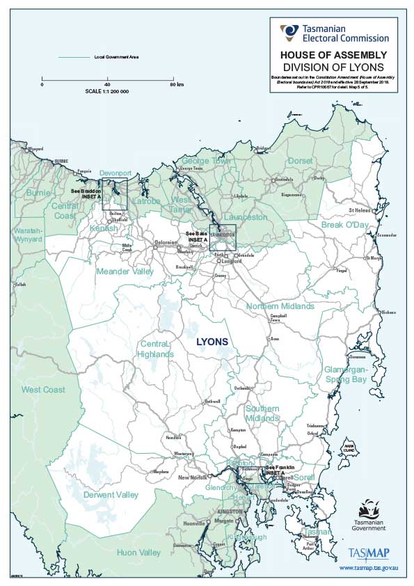
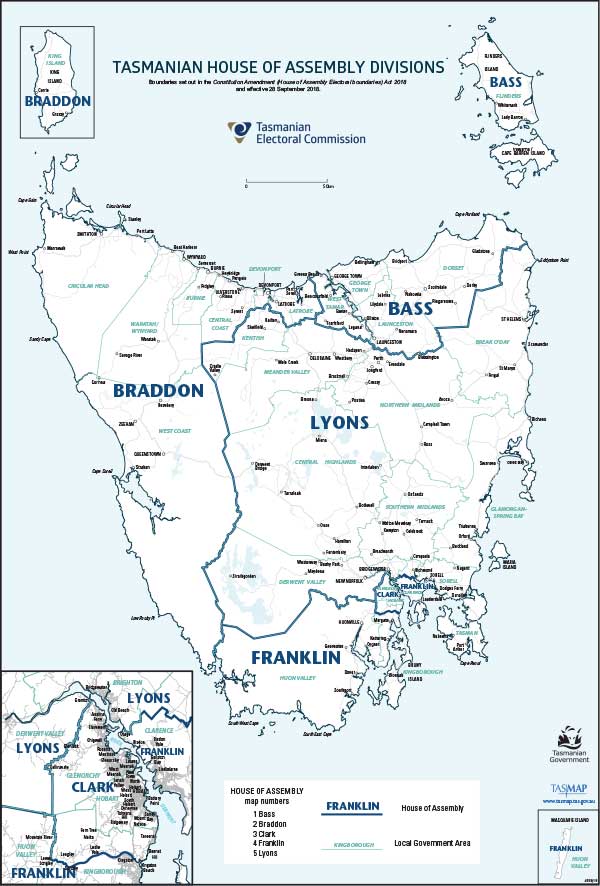
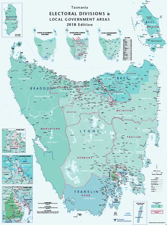
House of Assembly Divisions


 For maps relating to Tasmanian Legislative Council (Upper House) elections, click here.

Following amendments to the Constitution Act, which gained Royal Assent on 28 September 2018, House of Assembly electoral names and boundaries were updated to match changes to Federal divisions.

Learn more about the federal redistribution at the Australian Electoral Commission (AEC) website 

We have a range of interactive ways of showing your electoral boundaries:

 Printable, colour A4 maps showing simple details.

 'LISTmap' - an online, interactive map where you can switch layers of detail on and off.

There are five House of Assembly divisions:

Bass, Braddon, Clark, Franklin and Lyons.

These divisions have the same boundaries as the five Commonwealth House of Representatives divisions for Tasmania.

BASS BRADDON CLARK FRANKLIN LYONS Whole State maps
Preview of Bass division map

Bass

The Division of Bass takes its name from Dr George Bass (1771-1803), an early settler and explorer.

Bass encompasses an area of the north-east corner of Tasmania (7,975.96 sq km).

The division includes:

  • City of Launceston,
  • Dorset municipal area,
  • Flinders municipal area,
  • George Town municipal area,
  • West Tamar municipal area.


Preview of Braddon division map

Braddon

The Division of Braddon takes its name from Sir Edward Braddon (1829-1904), Premier of Tasmania (1894-99) and a Member of the House of Representatives (1901-04).

Prior to 1955, the Division of Braddon was known as the Division of Darwin.

Braddon encompasses an area of 21,369.24 sq km across the west and north-west coasts of Tasmania, along with King Island.

The division is focused on Burnie and Devonport and also includes:

  • City of Burnie,
  • Central Coast municipal area,
  • Circular Head municipal area,
  • City of Devonport,
  • King Island municipal area.
  • Latrobe municipal area,
  • Waratah-Wynyard municipal area,
  • West Coast municipal area.


Preview of Clark division map

Clark

The Division of Clark takes its name from Andrew Inglis Clark (1848-1907), an Australian founding father and the principal author of the Australian Constitution. He was Tasmania’s Attorney-General from 1887-92 and 1894-97. He proposed a modified version of the Hare electoral system which became Tasmanian law in 1896. This is now known as the Hare-Clark electoral system and it has been used Statewide since 1907.

Prior to 2018, the Division of Clark was known as the Division of Denison.

Clark is an inner metropolitan division centred in the greater Hobart region (292.26 sq km).

The division is centred on Hobart and includes:

  • City of Glenorchy,
  • City of Hobart,
  • part of the Kingborough municipal area.


Preview of Franklin division map

Franklin

The Division of Franklin takes its name from Sir John Franklin (1786-1847), Lieutenant-Governor of Tasmania (1837-43).

Franklin is an outer metropolitan division encompassing an area of 10,009.23 sq km to the south and east of Hobart.

The division includes:

  • Huon Valley municipal area,
  • City of Clarence,
  • part of the Kingborough municipal area.

The Division of Franklin includes Macquarie Island.


Preview of Lyons division map

Lyons

The Division of Lyons takes its name from the only Tasmanian to be elected as Prime Minister, Joseph Lyons (1879-1939), who was Prime Minister between 1932 and 1939 and his wife, Dame Enid Lyons (1897-1981). Dame Enid was the first female member of the House of Representatives and was also the first female cabinet member, when she was elected in 1943 and appointed in 1949 respectively.

Prior to 1984, the Division of Lyons was known as the Division of Wilmot.

Lyons is a large rural division of 35,721.83 sq km.

The division includes:

  • Break O'Day municipal area,
  • Brighton municipal area,
  • Central Highlands municipal area,
  • Derwent Valley municipal area,
  • Glamorgan-Spring Bay municipal area,
  • Kentish municipal area,
  • Meander Valley municipal area,
  • Northern Midlands municipal area,
  • Sorell municipal area,
  • Southern Midlands municipal area,
  • Tasman municipal area,
  • Part of the City of Clarence.


Preview of Bass division map

Whole of State

A statewide map displaying the boundaries of all five House of Assembly divisions.


Preview of Whole of State composite map

Whole of State (composite map)

A statewide map displaying the boundaries of House of Assembly divisions, Legislative Council divisions and Local Government municipal areas.


Who Represents You?

Use this simple search tool to learn who currently represents you at each level of government.


Historical boundaries

Maps of past House of Assembly boundaries:

2009-2018

Bass | Braddon | Denison | Franklin | Lyons | Whole of State  Effective 27 April 2009.

2000-2009

Whole of state composite map including divisions of Bass, Braddon, Denison, Franklin and Lyons. House of Assembly boundaries effective 14 July 2000.

1992-2000

Whole of state composite map including divisions of Bass, Braddon, Denison, Franklin and Lyons. House of Assembly boundaries effective 30 July 1992.